How a Small Maryland City Is Competing with Georgetown
In October of 1976, a massive hundred-year flood hit Frederick, Maryland, causing upwards of $25 million in damages overnight. Ron Young, then mayor, took to a helicopter to survey the extent of the damage to the small city about 45 miles north of Washington, DC. He feared that he was looking at a devastating setback to the work he started two years earlier to revive the economically-depressed downtown area.
As he flew above the 20 acres of flooded nineteenth-century buildings that comprised his historic hometown, he could not have imagined that these same waters would eventually help more than hinder the recovery.
At first, Young just wanted to rein in Carroll Creek, the little stream that provided waterpower to the mills and tanneries that formed the center of town in the eighteenth century. The creek had always flooded periodically, but suburban sprawl developing on the west side of town was making matters worse. In addition to draining the downtown of economic vitality, new shopping centers with their expansive parking lots had reduced ground permeability. Heavy rains were resulting in heavy runoff flowing directly into the creek from all the newly paved surfaces.
In a Frederick Post article dated April 24, 1974, an engineer warned that without a plan to control the creek, the city could face severe flooding every five years. But even as that doomsday prediction became reality two years later when a storm brought 7.5 inches of rain in a single night, the will to solve the problem was overcome by a lack of reasonable options.
“We commissioned a study that came back with several solutions,” Young said in a recent interview. “The first goal would have been to hold the water to the west so it didn’t flood downtown, but there was no place to hold it. The second alternative was to remove everything from the floodplain, which would have eliminated downtown. A third alternative … would have been a 150-foot-wide concrete ditch, which would have divided the town in half and been as ugly as all get out.”
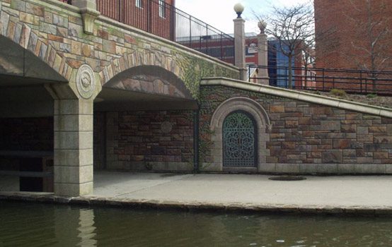
Facing the possible end of their downtown, the city introduced an ambitious and expensive proposition. They wanted to build four concrete tunnels, each large enough to accommodate a Greyhound bus, that would carry the bulk of the creek water underground from Baker Park in the west through the center of town out to an undeveloped area in the east. Above and between the tunnels would sit a false creek, a concrete canal about thirty feet wide and four to five feet deep that would always maintain the same water level no matter the severity of weather.
Initial estimates for the plan came in around $45 million, about four times the city’s annual operating budget at that time. To make the project work, the city would need a buy-in from the state.
“The big thing we sold [to the state] was economic development,” Young said. “There was money for economic development. There wasn’t money for flood control.”
The economic boost was to come from a planned linear park built along the canal with a mix of retail and office space next to public walkways, fountains, picnic areas and event spaces on both sides of the canal, connected by new pedestrian and car bridges. Not only would the new park area generate revenue, it would clean up the eyesores and pollution left along the creek by the town’s collapsed and abandoned industrial infrastructure, which had been out of commission since World War I.
While not included in the initial estimate, the promise of economic development enabled a deal to start building the flood-control project with joint funding from the city, county, and state. After traversing environmental impact studies and the federal and state bureaucratic morass, the project broke ground in October of 1985, but there was a long way to go.
The proposed park was met with loud objections from the start. Long-time residents worried that it was designed to benefit tourists and investors more than locals, and that the entire thing was already too expensive and full of unforeseen costs. The term “white elephant” was thrown around in regard to planned parking garages near the creek area.
Young’s original plans for the park were nearly as elaborate as the San Antonio River Walk that served as his inspiration, and they relied heavily on proposed but uncertain private/public partnerships. A quick perusal of local news headlines from the first 20 years of the project shows private investors becoming hot and cold on development plans as they gauged changes in the market.
The mayor’s case with critics wasn’t helped when the negotiating rights to build a major commercial complex on the creek were granted to a private firm whose principal partner chaired the city commission formed by Young to guide the development of the linear park.
In June of 1989, the state prosecutor’s office released a report of their investigation into the matter that concluded without criminal charges, but Young lost the mayoral election later that year, ending his 16-year tenure and leaving the fate of the heavily-criticized park project in doubt.
The flood control aspect was completed shortly after Young’s departure, but the development of the park overlay was put on hold, leaving the area along the new canal almost as aesthetically offensive as the rotting industrial district it had replaced.
Kara Norman, the president of the Downtown Frederick Partnership, which formed in 1990, said the pathways along the canal looked like “airplane landing strips, just these big, vast strips of concrete.”
It was unclear what role, if any, this desolate area would play in the economic rejuvenation of downtown, especially since more traditional urban regeneration efforts had already led to great improvements from the low point of mass retail abandonment in the late 1960s.
Young maintains that the downtown was always safe, but was widely perceived as a high-crime area—and he worked hard to change that perception. He ordered over 1,000 trees to be planted along the sidewalks, added street lamps, buried the power lines underground, and stepped up building-code enforcement.
He also successfully campaigned to keep county government offices from moving out to the suburbs and oversaw the construction of a new courthouse, bringing with it a cadre of private law offices and a resulting lunch crowd for local sandwich shops.
Slowly, people from the suburbs felt more comfortable spending time downtown. By the early 1990s, the seedy bars and greasy spoons had been replaced by sit-down restaurants, clothing shops, antique stores, coffee shops, and art studios. It wasn’t the same town anchored by big department stores that old-timers remembered, but it was a town again.
Young feels that because the linear park plans were halted following his ouster, the creek project didn’t have much to do with town improvements beyond removing Frederick from the floodplain. He said it didn’t begin contributing to the city economy until the mid-2000s when his original plans for the park were implemented on a reduced scale, and even now he believes that the creek’s contribution will remain modest until it is further developed.
But the Downtown Partnership began to see fruit from the creek area in the mid-to-late 1990s. Even ugly public space was still public space, something that the business district had never had in its tightly built eighteenth-century street grid, which didn’t even include a small square in front of the old town hall.
The Partnership now had a place to host special events that drew massive shopping crowds downtown for the first time since the retail heyday of the 1950s. When the bare concrete canal was lined with tents showcasing local businesses, art, and agriculture, it became possible to forget that the space had been relegated to the realm of teens on skateboards during the workweek.
Around the same time the business community was getting a boost from the new event space, a prominent local artist saw all of that concrete as a blank canvas. William Cochran, who has major public art installations in cities throughout the Baltimore-Washington metropolitan area, wanted to get his hands on the plain concrete bridge that carried cars over the creek near the city’s new nonprofit visual arts center.
Dubbing the project the Community Bridge Mural, Cochran created a massive trompe l’oeil mural which, when viewed from a distance, gives the illusion that the bridge is constructed of old stonework. On closer inspection, one can see symbols of the community embedded among the stones. The work received national attention, drawing tens of thousands of visitors to an area of town seldom seen by local residents.
The nationally-recognized artwork, combined with the increasing number of special events along the creek, generated renewed interest in the linear park concept among the public and at City Hall.
In the summer of 2004, the city began work on what would become the central section of the linear park. By the following year, the bare concrete sections between Market Street—the town’s main traffic corridor—and the bridge mural were covered in brick. Then came two elaborate pedestrian bridges, three new fountains built into the canal, a 350-seat amphitheater, and little green spaces with big shade trees and flowers.
Then a large commercial building was opened by a private investor along the north side of the creek and leased out to a variety of eateries that included outdoor seating. A four-story condominium complex was placed on the south side, immediately across the creek from the eateries.
In October 2006, thirty years after the flood, the city held an official dedication of the linear park. It didn’t have the canal islands, gondola boats, massive picnic areas, ice skating pond, or as much commercial development as Young planned. Indeed, a large section of the project east of the bridge mural was still just bare concrete.
But according to Norman, the new attraction downtown helped take Frederick “to the next level” by giving the city one more thing to advertise to visitors and investors. She credits the new park with ending a period of stagnation in the downtown business community.
Trendy foodie restaurants supplied by local county farms now joined the quaint family diners and sandwich shops. The coffee shops were joined by loose-leaf teashops. New distilleries, breweries, and wineries sprang up. Celebrity chef Bryan Voltaggio, a town native, opened a high-end restaurant in an old Frederick mansion. Zoe’s Chocolate Co., a tiny confectionary on Market Street, became the official chocolatier of the 2013 Academy Awards after just a few years in business.
After investors and city officials saw ten years of sustained growth and the public came to enjoy the linear park, money was budgeted to finish the section east of the bridge mural. The canal was expanded to include a large pond with dancing water resembling a miniature version of the Bellagio in Las Vegas. The concrete was bricked over and lined with street lamps and park benches. More green space was added. An industrial-style pedestrian bridge now connects the two sides of the creek on the eastern half of the park.
By the 40th anniversary of the flood, a 1.3 mile-long park sat atop the creek that nearly destroyed the town. And more development is still in the works. Over $150 million in private investment is planned. Including a hotel and conference center, a new tech startup with a creek-front café for the public, and an expansive park between the terminus of the flood control project and Monocacy River.
It’s impossible to say whether the struggling downtown would have ever recovered from a trajectory of decline without the 1976 flood and the resulting linear park. But it’s also difficult to look at the downtown today and call the linear park anything less than a complete success.
With its historic architecture and trendy business district, Frederick is now frequently compared to the Georgetown neighborhood of Washington, D.C. But it has managed to largely avoid the displacement of working and middle-class families normally associated with gentrification. Family homes in the heart of the historic district start as low as $250,000 and apartments for singles can still be found for under $1,000 per month. The city has even recently invested in building several low-cost housing options that conform with the historical architectural character. Somehow, the simple addition of pleasant walkable public space vastly improved the overall quality of life for everyone in the town—all without pricing out economic diversity.
Ironically, it’s now the suburban areas on the western side of town that need help. Fifty years ago, the word “customer” became synonymous with “motorist.” Today, the vast parking lots that flood the town creek with dirty runoff water stand largely empty. The Frederick Towne Mall shut its doors in 2013 after a painfully slow death, and many of the other strip-mall anchors along the western corridor have low patronage and high turnover.
A special committee of suburban business and property owners has been formed to revive the sprawling area locally called “The Golden Mile.” So far, few major changes have been implemented, but most of the proposed solutions involve making the sprawl more like the downtown that it nearly destroyed.
Erik Anderson is a freelance writer from Frederick, Md. who covers local history, arts, features and entertainment. His work has appeared in The Frederick News-Post, The Journal (Martinsburg, W.Va.), Find It Frederick, and the Montgomery County Sentinel. Follow New Urbs on Twitter for a feed dedicated to TAC’s coverage of cities, urbanism, and place.


Comments